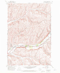
1967 Map of Huntsville
USGS Topo · Published 1971About this map
Touchet Valley serves as the primary corridor for movement and settlement on this 1960s landscape, where the Touchet River is closely paralleled by competing rail lines. Both the Union Pacific and the Burlington Northern railroads trace the valley floor, supporting agricultural infrastructure like the Grain Elevators near the Columbia Sch. The small settlements of Huntsville, Varna, and Dumas are anchored to this transit spine, while the surrounding high ground is dissected by numerous family-named canyons such as Whetstone Hollow and Hogeye Hollow. Cultural landmarks of the mid-century era are visible along the valley, including the Touchet Valley Airfield and a Drive-in Theater. Historical continuity is represented by the Lewis & Clark Trail State Park and the local Huntsville Cem, providing a detailed look at the rural intersection of Columbia and Walla Walla counties.
Find a feature on this map
32 named features on this map. Tap any name to fly to it.
Don’t see what you’re looking for? This feature index may not catch every label — zoom into the map to look around manually.
Map Details
Editions of this 1967 Huntsville Map
This is the sole edition of this map. No revisions or reprints were ever made.
Other maps of this area

1919 · Walla Walla
USGS Topo · 1:125,000

1921 · Walla Walla
USGS Topo · 1:125,000

1937 · Pomeroy
USGS Topo · 1:96,000

1942 · Pomeroy
USGS Topo · 1:125,000

1953 · Walla Walla
USGS Topo · 1:250,000

1955 · Pullman
USGS Topo · 1:250,000

1958 · Pullman
USGS Topo · 1:250,000

1958 · Walla Walla
USGS Topo · 1:250,000

1966 · Dixie
USGS Topo · 1:24,000
1966 · Coppei
USGS Topo · 1:24,000