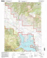
1998 Map of Huntsville
USGS Topo · Published 2001About this map
Pineview Reservoir dominates the heart of Ogden Valley, illustrating the complex water management systems used to sustain the surrounding settlements of Liberty, Eden, and Huntsville. By the late 1990s, the landscape reflects a transition from traditional mining and agriculture toward recreation and seasonal residency, evidenced by the Powder Mountain Ski Area near the Weber and Cache county line. Evidence of early infrastructure remains visible through the Union Pacific Railroad (Abandoned) corridor and numerous water features like the Ogden Valley Canal and Holmes-Ferrin Ditch. Local history is anchored by several burial grounds, including Mountain View Cemetery and Meadow View Cem, while smaller mining operations such as Shanghai Creek No 1 Mine and the Hidden Hole No 1 Mine appear in the southern mountains. The map also captures developed recreational sites like Quist Beach Picnic Area and the Anderson Cove Campground, showcasing the area's role as a regional destination.
Find a feature on this map
60 named features on this map. Tap any name to fly to it.
Don’t see what you’re looking for? This feature index may not catch every label — zoom into the map to look around manually.
Map Details
Editions of this 1998 Huntsville Map
This is the sole edition of this map. No revisions or reprints were ever made.
Other maps of this area

1954 · Ogden
USGS Topo · 1:250,000

1955 · Ogden
USGS Topo · 1:24,000

1955 · Mantua
USGS Topo · 1:24,000

1955 · Huntsville
USGS Topo · 1:24,000

1955 · James Peak
USGS Topo · 1:24,000

1955 · North Ogden
USGS Topo · 1:24,000

1955 · Snow Basin
USGS Topo · 1:24,000

1958 · Ogden
USGS Topo · 1:250,000

1960 · Ogden
USGS Topo · 1:250,000

1961 · Morgan
USGS Topo · 1:62,500