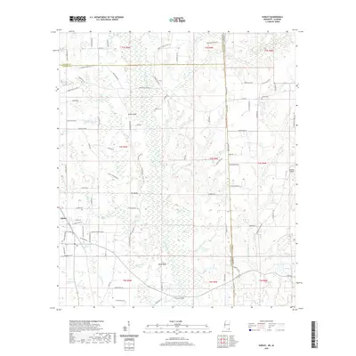
2020 Map of Hurley
USGS Topo · Published 2020About this map
Hurley sits at the western edge of this coastal plain landscape, where the flat terrain is deeply defined by the winding course of the Escatawpa River. The river corridor is marked by several distinctive bluffs, including Yellow Bluff, Red Bluff, and White Bluff, which overlook the expansive bottomlands and the Black Creek Swamp. This area, straddling the state line between Mississippi and Alabama, shows a rural settlement pattern anchored by family-named infrastructure such as Browns Bridge and smaller landmarks like Devils Den Bay. Genealogy researchers will find interest in the documented locations of Tanners Cem and Joyner Cem. The presence of the Skywest Airpark suggests a modern layer of transport superimposed over a landscape still largely dictated by its complex hydrology and numerous tributaries like Wallace Cr and Spring Creek.
Find a feature on this map
102 named features on this map. Tap any name to fly to it.
Don’t see what you’re looking for? This feature index may not catch every label — zoom into the map to look around manually.
Map Details
Editions of this 2020 Hurley Map
This is the sole edition of this map. No revisions or reprints were ever made.
Other maps of this area

1941 · Hurley
USGS Topo · 1:62,500

1941 · Vancleave
USGS Topo · 1:62,500

1941 · Lucedale
USGS Topo · 1:62,500

1942 · Wilmer
USGS Topo · 1:62,500

1943 · Lucedale
USGS Topo · 1:62,500

1943 · Hurley
USGS Topo · 1:62,500

1943 · Vancleave
USGS Topo · 1:62,500

1944 · Wilmer
USGS Topo · 1:62,500

1944 · Vancleave
USGS Topo · 1:62,500

1953 · Mobile
USGS Topo · 1:250,000