
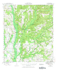
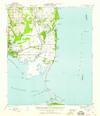
1941 Map of Hurley
USGS Topo · Published 1953About this map
The Pascagoula River creates a wide, swampy corridor through this landscape, flanked by a sequence of riverfront landmarks like Yellow Bluff, Cowards Bluff, and Miles Bluff. To the east of the river valley, the terrain transitions into the upland settlements of Hurley and Hamilton, where a network of rural roads such as Government Road and the Alabama Mississippi Road connect scattered community centers. The geography reveals a deeply established social fabric evidenced by numerous rural institutions, including Roberts Chapel, Shady Grove Cem, and Union Sch. On the eastern edge, the emerging aviation infrastructure of the Mobile Airport contrasts with the traditional river-and-rail economy of the Mississippi Export line. Along the river, features like Slaughter Flat Landing and Galloway Landing point to the area's history of water-based transport and commerce.
Find a feature on this map
64 named features on this map. Tap any name to fly to it.
Don’t see what you’re looking for? This feature index may not catch every label — zoom into the map to look around manually.
Map Details
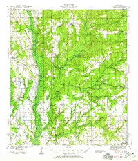
Editions of this 1941 Hurley Map
3 editions found
Other maps of this area
1921 · Grand Bay
USGS Topo · 1:62,500

1921 · Delchamps
USGS Topo · 1:62,500

1922 · Mobile
USGS Topo · 1:62,500
1940 · Mobile
USGS Topo · 1:62,500
1941 · Cedar Point
USGS Topo · 1:62,500

1941 · Vancleave
USGS Topo · 1:62,500
1941 · Creola
USGS Topo · 1:62,500

1941 · Lucedale
USGS Topo · 1:62,500

1942 · Kushla
USGS Topo · 1:31,680
1942 · Theodore
USGS Topo · 1:31,680