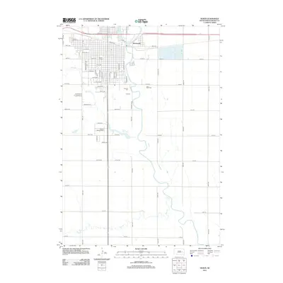
2012 Map of Huron
USGS Topo · Published 2012About this map
The James River snakes through the eastern half of this South Dakota landscape, providing a natural boundary for the expansion of Huron. In the northern reaches of the settlement, Huron College serves as a central landmark within the city grid, while the community of Morningside sits just east of the river bend. The transition from urban streets to rural prairie is marked by a series of significant burial grounds, including Riverside Cem, Ideal Cem, and Saint Martin Cem, which are clustered along the river's western bluffs. Further south, the terrain opens into wide agricultural sections drained by Cain Cr and Stony Run, where Stony Run Lake and the Restlawn Memory Garden break the geometric pattern of the section lines.
Find a feature on this map
67 named features on this map. Tap any name to fly to it.
Don’t see what you’re looking for? This feature index may not catch every label — zoom into the map to look around manually.
Map Details
Editions of this 2012 Huron Map
This is the sole edition of this map. No revisions or reprints were ever made.
Other maps of this area

1898 · Huron
USGS Topo · 1:125,000

1953 · Huron
USGS Topo · 1:250,000

1954 · Huron
USGS Topo · 1:250,000

1957 · Forestburg NE
USGS Topo · 1:24,000

1957 · Cavour
USGS Topo · 1:24,000

1957 · Huron
USGS Topo · 1:24,000

1958 · Forestburg NW
USGS Topo · 1:24,000

1958 · Huron NW
USGS Topo · 1:24,000
1958 · Huron NE
USGS Topo · 1:24,000

1973 · Alpena
USGS Topo · 1:24,000