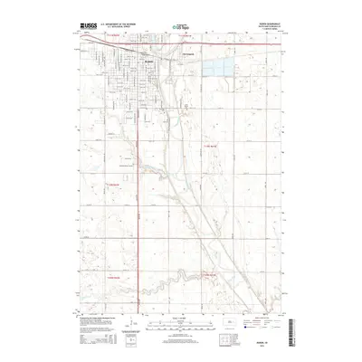
2015 Map of Huron
USGS Topo · Published 2015About this map
The Huron city center and its eastern expansion into Morningside dominate this 2015 study of Beadle County. The urban grid is defined by prominent north-south thoroughfares such as Dakota Ave and Lincoln Ave SW, which give way to the winding course of the James River as it flows southward past the Riverside Cem and Ideal Cem. The landscape outside the city limits is characterized by the prairie drainage systems of Stony Run and Cain Cr, which feed into several local water bodies including Stony Run Lake and Ravine Park Lake. Genealogists will find a high concentration of burial sites documented here, including the Saint Martin Cem and the extensive Restlawn Memory Garden. The transition from the structured residential blocks of Huron to the more open sections of T111N R61W illustrates the area's continued reliance on a mix of urban development and the surrounding watershed.
Find a feature on this map
102 named features on this map. Tap any name to fly to it.
Don’t see what you’re looking for? This feature index may not catch every label — zoom into the map to look around manually.
Map Details
Editions of this 2015 Huron Map
This is the sole edition of this map. No revisions or reprints were ever made.
Other maps of this area

1898 · Huron
USGS Topo · 1:125,000

1953 · Huron
USGS Topo · 1:250,000

1954 · Huron
USGS Topo · 1:250,000

1957 · Forestburg NE
USGS Topo · 1:24,000

1957 · Cavour
USGS Topo · 1:24,000

1957 · Huron
USGS Topo · 1:24,000

1958 · Forestburg NW
USGS Topo · 1:24,000

1958 · Huron NW
USGS Topo · 1:24,000
1958 · Huron NE
USGS Topo · 1:24,000

1973 · Alpena
USGS Topo · 1:24,000