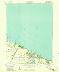
1959 Map of Huron
USGS Topo · Published 1961About this map
Lake Erie defines the northern reaches of this mid-century survey, where the Huron River meets the lake at the industrial and maritime hub of Huron. The landscape reflects a transition from organized municipal centers to a series of lakefront residential developments such as Rye Beach, Chaska Beach, and Oberlin Beach. The New York Central railroad corridor bisects the area, providing the primary east-west transport link through the township of Huron and into neighboring Berlin.
Find a feature on this map
31 named features on this map. Tap any name to fly to it.
Don’t see what you’re looking for? This feature index may not catch every label — zoom into the map to look around manually.
Map Details
Editions of this 1959 Huron Map
This is the sole edition of this map. No revisions or reprints were ever made.
Other maps of this area

1903 · Vermilion
USGS Topo · 1:62,500

1904 · Sandusky
USGS Topo · 1:62,500

1916 · Kelleys Island
USGS Topo · 1:62,500

1919 · Kelleys Island
USGS Topo · 1:62,500

1956 · Toledo
USGS Topo · 1:250,000

1959 · Kimball
USGS Topo · 1:24,000

1959 · Milan
USGS Topo · 1:24,000

1959 · Sandusky
USGS Topo · 1:24,000

1959 · Berlin Heights
USGS Topo · 1:24,000

1959 · Vermilion West
USGS Topo · 1:24,000