1903 Map of Vermilion
USGS Topo · Published 1932About this map
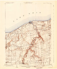
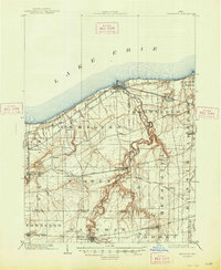
Lake Erie defines the northern reaches of this coastal landscape, where the Vermilion River carves a deep, winding path through the clay banks of northern Ohio. At the turn of the century, the shoreline was a bustling corridor for both transportation and commerce, dominated by the Lake Shore and Michigan Southern and the New York Chicago and St. Louis railroads. The map highlights the early transit networks of the era, including the Lake Shore Electric railway and the (Sandusky and Cleveland Line). Inland, the survey captures several small agricultural and industrial communities such as Birmingham, Ashmont, and Florence. A notable industrial feature is the Quarry located in Amherst, indicating the region's reliance on natural stone extraction alongside the maritime activity at Vermilion. Small creek systems like Chappel Creek and Cranberry Creek drain the surrounding townships, marking the transition from the lakefront to the rural interior of Erie and Lorain counties.
Find a feature on this map
45 named features on this map. Tap any name to fly to it.
Don’t see what you’re looking for? This feature index may not catch every label — zoom into the map to look around manually.
Map Details
Editions of this 1903 Vermilion Map
2 editions found
Historical Maps of Lorain Through Time
1 maps found