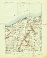
1903 Map of Vermilion
USGS Topo · Published 1948About this map
The winding Vermilion River carves a deep valley through the heart of the northern Ohio lakefront, as documented by geographer Jno.H.Renshawe during the first years of the twentieth century. Along the shore of Lake Erie, the town of Vermilion serves as a primary hub where the Lake Shore and Michigan Southern railroad meets the water. The landscape is defined by the intersection of rail and industry, notably the large Quarry located near the Black River and the diverse network of the Cleveland Elyria and Western Electric line connecting inland settlements. Small agricultural and commuter stops such as Berlin Heights, Brownhelm Station, and Axtel punctuate the grid, while the southern reaches of the quadrangle near Wakeman show the transition to the more rural drainage basins of Chappel Creek and Old Woman Creek.
Find a feature on this map
40 named features on this map. Tap any name to fly to it.
Don’t see what you’re looking for? This feature index may not catch every label — zoom into the map to look around manually.
Map Details
Editions of this 1903 Vermilion Map
2 editions found
Other maps of this area

1901 · Oberlin
USGS Topo · 1:62,500

1903 · Vermilion
USGS Topo · 1:62,500

1903 · Oberlin
USGS Topo · 1:62,500

1904 · Sandusky
USGS Topo · 1:62,500

1904 · Wellington
USGS Topo · 1:62,500

1906 · Wellington
USGS Topo · 1:62,500

1908 · New London
USGS Topo · 1:62,500

1915 · Norwalk
USGS Topo · 1:62,500

1916 · Kelleys Island
USGS Topo · 1:62,500

1919 · Kelleys Island
USGS Topo · 1:62,500