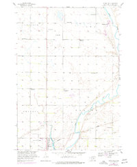
1958 Map of Huron NW
USGS Topo · Published 1977About this map
Riverside Colony and the agricultural landscape of Fairfield and Iowa townships characterize this 1950s survey of the plains north of Huron. The map reveals a transition in rural education, marking several shuttered sites including Edison Sch, Morrill Sch, and Lindbergh Sch, while Whittier Sch and School No 3 remained as active landmarks of the school district. The meandering James River cuts through the eastern half of the quadrangle, flanked by numerous Gravel Pits that suggest local industry in the mid-century. Development is concentrated near the southern margin, where the Huron Regional Airport, the Burlington Northern railroad, and Ravine Park Lake signify the infrastructure supporting this regional hub.
Find a feature on this map
21 named features on this map. Tap any name to fly to it.
Don’t see what you’re looking for? This feature index may not catch every label — zoom into the map to look around manually.
Map Details
Editions of this 1958 Huron NW Map
2 editions found
Other maps of this area

1895 · Byron
USGS Topo · 1:125,000

1898 · Huron
USGS Topo · 1:125,000

1953 · Huron
USGS Topo · 1:250,000

1954 · Huron
USGS Topo · 1:250,000

1956 · Lake Byron
USGS Topo · 1:24,000

1956 · Lake Byron SE
USGS Topo · 1:24,000

1956 · Hitchcock SE
USGS Topo · 1:24,000

1957 · Cavour
USGS Topo · 1:24,000

1957 · Huron
USGS Topo · 1:24,000

1958 · Huron NW
USGS Topo · 1:24,000