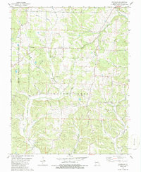
1980 Map of Hurricane
USGS Topo · Published 1986About this map
The hills of Union township and the Mark Twain National Forest define this 1980s landscape in Bollinger County. Rural life centers on a network of country churches and family burial grounds, including Liberty Ch, Mt Carmel Ch, and the Old Concord Cem. The map reveals the path of an Old Railroad Grade winding through the south, a clear marker of the area's former timber or transit infrastructure. Small settlements such as Tallent, Younts Store, and the namesake community of Hurricane are linked by a complex drainage system of creeks, most notably Crooked Creek and Little Whitewater Creek. The terrain is characterized by steep ridges and hollows, such as Gum Hollow, which likely dictated the placement of early homesteads and the numerous cemeteries like Slinkard Cem and Berry Cem that preserve the names of the region's early families.
Find a feature on this map
50 named features on this map. Tap any name to fly to it.
Don’t see what you’re looking for? This feature index may not catch every label — zoom into the map to look around manually.
Map Details
Editions of this 1980 Hurricane Map
2 editions found
Other maps of this area

1910 · Higdon
USGS Topo · 1:62,500

1923 · Perryville
USGS Topo · 1:62,500

1924 · Perryville
USGS Topo · 1:62,500

1933 · Marble Hill
USGS Topo · 1:62,500

1933 · Marquand
USGS Topo · 1:62,500

1937 · Marble Hill
USGS Topo · 1:62,500

1938 · Marquand
USGS Topo · 1:62,500

1949 · Paducah
USGS Topo · 1:250,000

1949 · Rolla
USGS Topo · 1:250,000

1950 · Paducah
USGS Topo · 1:250,000