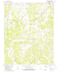
1980 Map of Hurricane
USGS Topo · Published 1980About this map
Crooked Creek meanders through the heart of the eastern Ozarks, defining the drainage patterns of a landscape dotted with small family farms and rural congregations in the late 1970s. The topographic detail highlights the cultural legacy of Union township, where community life centered around local landmarks such as Old Concord Cem and the New Bethel Ch. The presence of an Old Railroad Grade in the southwest corner near Grisham suggests the area's earlier connection to timber or mineral transport, even as much of the western terrain remained protected within the Mark Twain National Forest. Genealogical interest is particularly high here, with numerous small burial grounds like Slinkard Cem, McMahan Cem, and Hawn Cem scattered along the creek bottoms and ridge lines near the settlements of Patton and Tallent.
Find a feature on this map
47 named features on this map. Tap any name to fly to it.
Don’t see what you’re looking for? This feature index may not catch every label — zoom into the map to look around manually.
Map Details
Editions of this 1980 Hurricane Map
2 editions found
Other maps of this area

1910 · Higdon
USGS Topo · 1:62,500

1923 · Perryville
USGS Topo · 1:62,500

1924 · Perryville
USGS Topo · 1:62,500

1933 · Marble Hill
USGS Topo · 1:62,500

1933 · Marquand
USGS Topo · 1:62,500

1937 · Marble Hill
USGS Topo · 1:62,500

1938 · Marquand
USGS Topo · 1:62,500

1949 · Paducah
USGS Topo · 1:250,000

1949 · Rolla
USGS Topo · 1:250,000

1950 · Paducah
USGS Topo · 1:250,000