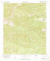
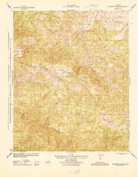
1964 Map of Hurricane Deck
USGS Topo · Published 1965About this map
Hurricane Deck stands as a prominent formation between two major river systems in the high back-country of the Los Padres National Forest. This mid-century survey reveals a landscape of limited access, dominated by the Sisquoc River to the north and the Manzana River to the south. Human presence is largely confined to a network of trails and remote outposts, including the South Fork Guard Station and several dispersed camps like the Happy Hunting Ground Campground and Lonnie Davis Campground. The map traces a topography defined by steep canyons and seasonal springs, such as Ernest Blanco Spring and Montgomery Spring. High-altitude meadows like the Montgomery Potrero provide contrast to the complex drainage patterns of Sweetwater Canyon and Abel Canyon. This document preserves the trail alignments and remote landmarks, including the petroglyph site at Painted Rock, as they existed before modern recreational developments changed the character of these protected lands.
Find a feature on this map
45 named features on this map. Tap any name to fly to it.
Don’t see what you’re looking for? This feature index may not catch every label — zoom into the map to look around manually.
Map Details
Editions of this 1964 Hurricane Deck Map
4 editions found
Other maps of this area

1902 · Santa Ynez
USGS Topo · 1:125,000

1905 · Santa Ynez
USGS Topo · 1:125,000

1941 · San Rafael Mtn.
USGS Topo · 1:62,500

1941 · McPherson Peak
USGS Topo · 1:62,500

1942 · San Rafael Mtn.
USGS Topo · 1:62,500

1943 · Big Pine Mountain
USGS Topo · 1:31,680

1943 · San Rafael Mtn.
USGS Topo · 1:62,500

1943 · McPherson Peak
USGS Topo · 1:62,500

1943 · Cuyama Ranch
USGS Topo · 1:31,680
1944 · Salisbury Potrero
USGS Topo · 1:31,680