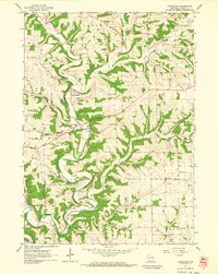
1962 Map of Hurricane
USGS Topo · Published 1964About this map
Grant River and its numerous tributaries, including the Little Grant River and Pigeon Creek, define the dissected topography of this corner of Grant County in the early 1960s. The settlement pattern is largely agricultural, punctuated by small crossroads and community hubs like Hurricane and the vanished post office locale of Flora Fountain. Several township boundaries, including Beetown and Little Grant, intersect here, revealing the enduring 19th-century administrative structure of the Wisconsin driftless area.
Find a feature on this map
27 named features on this map. Tap any name to fly to it.
Don’t see what you’re looking for? This feature index may not catch every label — zoom into the map to look around manually.
Map Details
Editions of this 1962 Hurricane Map
2 editions found
Other maps of this area

1900 · Lancaster
USGS Topo · 1:125,000

1904 · Lancaster
USGS Topo · 1:125,000

1908 · Lancaster
USGS Topo · 1:125,000

1955 · Cassville
USGS Topo · 1:24,000

1955 · Balltown
USGS Topo · 1:24,000

1957 · Potosi
USGS Topo · 1:24,000

1959 · Dubuque
USGS Topo · 1:250,000

1961 · Dubuque
USGS Topo · 1:250,000

1962 · Dubuque
USGS Topo · 1:250,000
1962 · Mount Hope
USGS Topo · 1:24,000