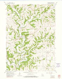
1962 Map of Hurricane
USGS Topo · Published 1981About this map
Grant River and its numerous tributaries carve a complex landscape of ridges and valleys through this portion of Grant County. The area is defined by its rural intersections and traditional social centers, such as Five Points and the small community of Hurricane. This 1962 field-checked survey reveals a high density of rural burial grounds, including the Pleasant View Cem, Pigeon Cem, and Morrell Cem, which often represent the last visible traces of early family farmsteads and 19th-century congregations. The presence of the Hurricane Sch suggests the continued role of local school districts in maintaining the social fabric of the driftless area before the era of widespread consolidation. Several Quarry sites dot the hillsides, highlighting the localized extraction of limestone typical of this Wisconsin region. Along the river bottoms, narrow corridors of timber follow Pigeon Creek and Blake Fork, while the upland plateaus remain dominated by open agricultural clearings.
Find a feature on this map
25 named features on this map. Tap any name to fly to it.
Don’t see what you’re looking for? This feature index may not catch every label — zoom into the map to look around manually.
Map Details
Editions of this 1962 Hurricane Map
2 editions found
Other maps of this area

1900 · Lancaster
USGS Topo · 1:125,000

1904 · Lancaster
USGS Topo · 1:125,000

1908 · Lancaster
USGS Topo · 1:125,000

1955 · Cassville
USGS Topo · 1:24,000

1955 · Balltown
USGS Topo · 1:24,000

1957 · Potosi
USGS Topo · 1:24,000

1959 · Dubuque
USGS Topo · 1:250,000

1961 · Dubuque
USGS Topo · 1:250,000

1962 · Dubuque
USGS Topo · 1:250,000
1962 · Mount Hope
USGS Topo · 1:24,000