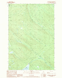
1989 Map of Hurricane Hill
USGS Topo · Published 1989About this map
Hurricane Hill stands as the central landmark of this North Woods survey, marking a terrain of dense timber and complex water networks in northern Somerset County. The international border between the Canada-US frontier is clearly delineated along the northwestern corner near Little St John Lake. The landscape is defined by the headwaters of numerous waterways, including the Middle Branch Norris Brook and South Branch Norris Brook, which drain through the township divisions of T 5 R 19 Wels and T 5 R 20 Wels. At the southern edge, Dole Pond serves as a significant drainage point for Dole Brook and Roberts Brook. Evidence of land use and remote access is visible through the presence of a Gravel Pit and an established Campsite, reflecting the region's character as a managed forest area and outdoor destination late in the twentieth century.
Find a feature on this map
18 named features on this map. Tap any name to fly to it.
Don’t see what you’re looking for? This feature index may not catch every label — zoom into the map to look around manually.
Map Details
Editions of this 1989 Hurricane Hill Map
This is the sole edition of this map. No revisions or reprints were ever made.
Other maps of this area

1927 · Sandy Bay
USGS Topo · 1:48,000

1930 · Sandy Bay
USGS Topo · 1:62,500

1944 · Sandy Bay
USGS Topo · 1:62,500

1949 · Jackman
USGS Topo · 1:250,000

1956 · Penobscot Lake
USGS Topo · 1:62,500

1957 · Norris Brook
USGS Topo · 1:62,500

1957 · Saint Zacharie
USGS Topo · 1:62,500

1962 · Quebec
USGS Topo · 1:250,000

1963 · Jackman
USGS Topo · 1:250,000

1966 · Sherbrooke
USGS Topo · 1:250,000