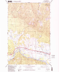
1984 Map of Huson
USGS Topo · Published 1984About this map
Huson sits at a critical junction of transport and water in this mid-1980s mountain landscape, where the Burlington Northern railroad and the Mullan Road follow the valley floor. The geography is defined by the significant descent from high points like Edith Peak in the north down to the Clark Fork river in the south. The intersection of natural watercourses and human engineering is evident in the Frenchtown Irrigation District Ditch, which draws from the surrounding drainages including Sixmile Creek and Houle Creek. Within the Lolo National Forest, the map reveals a network of resource-based infrastructure, from the Sixmile Trail (Pack) to several gravel pits and water tanks. The presence of an Old Railroad Grade near the Roman Creek confluence suggests the shifting path of industry and transit over time in Missoula County.
Find a feature on this map
27 named features on this map. Tap any name to fly to it.
Don’t see what you’re looking for? This feature index may not catch every label — zoom into the map to look around manually.
Map Details
Editions of this 1984 Huson Map
2 editions found
Other maps of this area

1912 · Missoula
USGS Topo · 1:125,000

1956 · Wallace
USGS Topo · 1:250,000

1956 · Hamilton
USGS Topo · 1:250,000

1959 · Hamilton
USGS Topo · 1:250,000

1959 · Alberton
USGS Topo · 1:62,500

1959 · Arlee
USGS Topo · 1:62,500

1960 · Wallace
USGS Topo · 1:250,000

1960 · Hamilton
USGS Topo · 1:250,000

1963 · Primrose
USGS Topo · 1:24,000

1964 · Hamilton
USGS Topo · 1:250,000