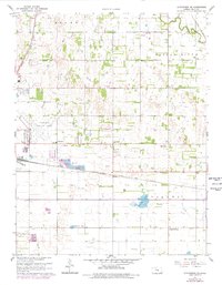
1961 Map of Hutchinson SE
USGS Topo · Published 1978About this map
Hutchinson Municipal Airport anchors the landscape of this Central Kansas survey, surrounded by the agricultural townships of Medora, Clay, and Valley. The mid-century transport network is clearly defined by three major rail lines, including the Atchison Topeka and Santa Fe and the Chicago Rock Island and Pacific. Small communities and named landmarks like Obeeville and Punkin Center punctuate the grid, while the Bethany Ch and a local Drive-in Theater serve as social markers for the era. Hydrological features such as Brandy Lake and the meandering Little River provide a natural contrast to the industrial presence of a Sandpit, various Oil Well sites, and a Mine. This 1961 edition, updated in the late 1970s, captures the transition between rural prairie life and the expanding infrastructure of the Reno County region.
Find a feature on this map
24 named features on this map. Tap any name to fly to it.
Don’t see what you’re looking for? This feature index may not catch every label — zoom into the map to look around manually.
Map Details
Editions of this 1961 Hutchinson SE Map
2 editions found
Other maps of this area

1889 · Cheney
USGS Topo · 1:125,000

1891 · Hutchinson
USGS Topo · 1:125,000

1891 · Cheney
USGS Topo · 1:125,000

1893 · Hutchinson
USGS Topo · 1:125,000

1901 · Cheney
USGS Topo · 1:125,000

1955 · Wichita
USGS Topo · 1:250,000

1955 · Hutchinson
USGS Topo · 1:250,000

1958 · Wichita
USGS Topo · 1:250,000

1958 · Patterson
USGS Topo · 1:24,000

1959 · Hutchinson
USGS Topo · 1:250,000