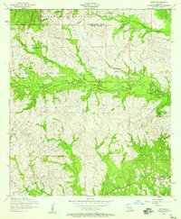
1954 Map of Hutton
USGS Topo · Published 1958About this map
Kisatchie National Forest dominates the northern reaches of this landscape, where the boundary between Natchitoches Parish and Vernon Parish traverses a network of winding watercourses. The small settlement of Hutton sits near the center of the sheet, surrounded by family-named landmarks and rural burial grounds like Robinson Cemetery and Ballview Cemetery. This 1954 field check captures the area during a period of transition for its local infrastructure, characterized by the extensive presence of a dismantled railroad that snakes across the terrain. The hydrology is defined by many small tributaries, including Comrade Creek, Mill Creek, and the curiously named Devil Swamp in the northeast. For genealogists and local historians, the specific locations of Welcome Cemetery and scattered rural structures provide a window into the mid-century community footprint of this part of central Louisiana.
Find a feature on this map
20 named features on this map. Tap any name to fly to it.
Don’t see what you’re looking for? This feature index may not catch every label — zoom into the map to look around manually.
Map Details
Editions of this 1954 Hutton Map
3 editions found
Other maps of this area

1937 · Chopin SW
USGS Topo · 1:31,680

1937 · Chopin NW
USGS Topo · 1:31,680

1941 · Slagle
USGS Topo · 1:62,500

1942 · Kisatchie
USGS Topo · 1:62,500

1943 · Leander
USGS Topo · 1:62,500

1943 · Kisatchie
USGS Topo · 1:62,500

1944 · Chopin
USGS Topo · 1:62,500

1944 · Slagle
USGS Topo · 1:62,500

1948 · Chopin
USGS Topo · 1:62,500

1953 · Alexandria
USGS Topo · 1:250,000