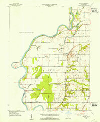
1952 Map of Hutton
USGS Topo · Published 1953About this map
The Wabash River forms a dynamic western boundary for this Vigo County landscape, shaping the terrain with sharp oxbows like Aurora Bend and several backwater bayous. In the early 1950s, the river remained a focal point for local transport and geography, evidenced by the Darwin Ferry crossing into Illinois. Inland, the community of Hutton serves as a central hub, surrounded by a network of family and community landmarks including Center Hill Ch and multiple burial grounds such as Shattuck Cem and Watson Cem. The land use shows a mix of traditional agriculture and emerging resource extraction, with clusters of Oil Wells appearing south of Vigo. Low-lying drainage patterns are well-defined by features like Nigger Creek and Greenfield Bayou, which snake through the bottomlands before reaching the primary river channel.
Find a feature on this map
36 named features on this map. Tap any name to fly to it.
Don’t see what you’re looking for? This feature index may not catch every label — zoom into the map to look around manually.
Map Details
Editions of this 1952 Hutton Map
This is the sole edition of this map. No revisions or reprints were ever made.
Other maps of this area

1932 · Marshall
USGS Topo · 1:62,500

1937 · Marshall
USGS Topo · 1:62,500

1940 · Pimento
USGS Topo · 1:24,000

1941 · Terre Haute
USGS Topo · 1:24,000

1942 · Fairbanks
USGS Topo · 1:24,000

1942 · Shelburn
USGS Topo · 1:24,000

1942 · Hutton
USGS Topo · 1:24,000

1942 · Dennison
USGS Topo · 1:24,000

1948 · Terre Haute
USGS Topo · 1:24,000

1952 · Fairbanks
USGS Topo · 1:24,000