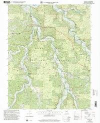
1999 Map of Huzzah
USGS Topo · Published 2002About this map
Huzzah Creek defines the geography of this Missouri landscape, winding through the heart of the Mark Twain National Forest. This late 20th-century survey illustrates a deeply rural Crawford County, where small settlements like Berryman and Westover are centered around local landmarks and natural springs. The topography is marked by distinctive limestone features, including the Lower Narrows and Upper Narrows, which dictate the paths of early roads and creek crossings. Family history is etched into the terrain through numerous burial sites, including Gibbs Cem, Keener Cem, and Sanders Cem, often located near hollows like Henpeck Hollow or Keener Hollow. Local enterprise is represented by the Fish Hatchery near Westover Spring, while the presence of the Ozark Trail and Roadside Park highlights the area's role in Missouri's outdoor recreation history.
Find a feature on this map
36 named features on this map. Tap any name to fly to it.
Don’t see what you’re looking for? This feature index may not catch every label — zoom into the map to look around manually.
Map Details
Editions of this 1999 Huzzah Map
This is the sole edition of this map. No revisions or reprints were ever made.
Other maps of this area

1903 · Sullivan
USGS Topo · 1:125,000

1932 · Steelville
USGS Topo · 1:48,000

1933 · Steelville
USGS Topo · 1:62,500

1937 · Steelville
USGS Topo · 1:62,500

1943 · Berryman
USGS Topo · 1:62,500

1945 · Berryman
USGS Topo · 1:62,500

1947 · Sullivan
USGS Topo · 1:62,500

1948 · Leasburg
USGS Topo · 1:24,000

1949 · Saint Louis
USGS Topo · 1:250,000

1949 · Sullivan
USGS Topo · 1:62,500