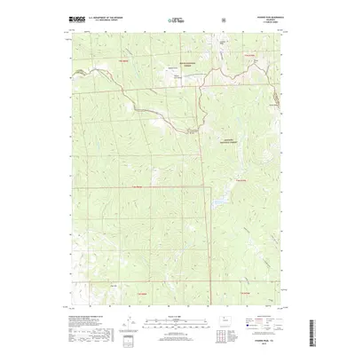
2019 Map of Hyannis Peak
USGS Topo · Published 2019About this map
Hyannis Peak and the Rabbit Ears Range anchor this high-elevation landscape along the boundary of Grand and Jackson Counties. The Continental Divide winds through the center of the sheet, followed closely by the Continental Divide National Scenic Trail, which provides a corridor through the transition between Routt National Forest and Arapaho National Forest. The map is defined by a dense network of high-country drainage systems, including Troublesome Cr and Middle Fork Arapaho Cr, which flow away from the prominent Arapaho Ridge. Scattered topographic landmarks like Grimes Peak, Coal Mtn, and Sheep Mtn overlook a terrain marked by glacial and fluvial features such as Lost Gulch and the seasonal basin of Matheson Reservoir.
Find a feature on this map
36 named features on this map. Tap any name to fly to it.
Don’t see what you’re looking for? This feature index may not catch every label — zoom into the map to look around manually.
Map Details
Editions of this 2019 Hyannis Peak Map
This is the sole edition of this map. No revisions or reprints were ever made.
Other maps of this area

1954 · Craig
USGS Topo · 1:250,000

1956 · Kremmling
USGS Topo · 1:62,500

1956 · Spicer Peak
USGS Topo · 1:24,000

1956 · Parkview Mountain
USGS Topo · 1:24,000

1956 · Buffalo Peak
USGS Topo · 1:24,000

1956 · Whiteley Peak
USGS Topo · 1:24,000

1956 · Hyannis Peak
USGS Topo · 1:24,000

1956 · Rand
USGS Topo · 1:24,000

1956 · Hyannis Peak
USGS Topo · 1:62,500

1956 · Rand
USGS Topo · 1:62,500