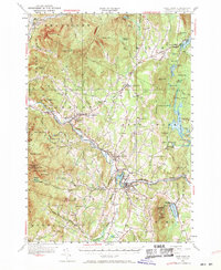
1953 Map of Hyde Park
USGS Topo · Published 1971About this map
The Lamoille River valley serves as the central artery for this mid-century Vermont landscape, where the St Johnsbury and Lake Champlain Railroad parallels the river's course through Johnson and Morrisville. In the village of Johnson, the State Teachers College stands as a significant cultural landmark, while nearby Ithiel Falls and Prospect Rock mark the rugged geography of the Green Mountains. The area's mid-century character is evident in the transition from traditional resource extraction, such as the Talc Mine north of Johnson, to emerging recreational spaces like the Drive In Theater near Lake Lamoille and the Copley Country Club. Settlement patterns remain concentrated in valley towns like Hyde Park and Eden, while the surrounding heights of Laraway Mtn and Bowen Mtn define the timbered upland. Water resources are plentiful, ranging from the expansive Green River Reservoir to smaller reaches like Zack Woods Pd and Lake Elmore, located within Elmore State Park.
Find a feature on this map
113 named features on this map. Tap any name to fly to it.
Don’t see what you’re looking for? This feature index may not catch every label — zoom into the map to look around manually.
Map Details
Editions of this 1953 Hyde Park Map
4 editions found
Other maps of this area

1919 · Montgomery
USGS Topo · 1:62,500

1919 · Montpelier
USGS Topo · 1:62,500

1920 · Franklin Pond
USGS Topo · 1:62,500

1920 · Montgomery
USGS Topo · 1:62,500

1920 · Irasburg
USGS Topo · 1:62,500

1921 · Richmond
USGS Topo · 1:48,000

1921 · Montpelier
USGS Topo · 1:62,500

1922 · Enosburg Falls
USGS Topo · 1:48,000

1923 · Irasburg
USGS Topo · 1:48,000

1924 · Camels Hump
USGS Topo · 1:62,500