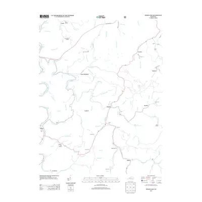
2013 Map of Hyden East
USGS Topo · Published 2013About this map
Buckhorn Lake dominates the northwest quadrant of this Leslie County landscape, where the waters of the Middle Fork Kentucky River are impounded among numerous hollows. The settlement pattern follows the narrow creek valleys, with communities like Wooton, Smilax, and Avawam established along the winding roads that trace the watercourses. This map reveals a deeply dispersed burial record, featuring numerous family and community cemeteries such as Hendrix Cem, Skeens Cem, and Raccoon Cem tucked into the hillsides. The Daniel Boone Pkwy provides a modern transit artery across the northern section, contrasting with the many smaller hollows like Persimmon Hollow and Dark Hollow that characterize the area's interior. Near the center, Jacks Point Lookout Tower stands as a prominent landmark overlooking the confluence of Big Willard Cr and Aces Br.
Find a feature on this map
97 named features on this map. Tap any name to fly to it.
Don’t see what you’re looking for? This feature index may not catch every label — zoom into the map to look around manually.
Map Details
Editions of this 2013 Hyden East Map
This is the sole edition of this map. No revisions or reprints were ever made.
Other maps of this area

1891 · Hazard
USGS Topo · 1:125,000

1913 · Buckhorn
USGS Topo · 1:62,500

1914 · Troublesome
USGS Topo · 1:62,500

1916 · Cornettsville
USGS Topo · 1:62,500

1916 · Hyden
USGS Topo · 1:48,000

1919 · Hyden
USGS Topo · 1:62,500

1953 · Buckhorn
USGS Topo · 1:24,000

1953 · Hyden West
USGS Topo · 1:24,000

1954 · Krypton
USGS Topo · 1:24,000
1954 · Hyden East
USGS Topo · 1:24,000