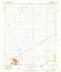
1965 Map of Hyder SE
USGS Topo · Published 1966About this map
Hyder Valley defines this arid landscape in the mid-1960s, a region where life and transport are shaped by the scarce water and the steel of the railroad. The settlement of Hyder sits along the Southern Pacific tracks, serving as a vital rail point in a desert expanse marked by seasonal drainages like Nottbusch Wash and Columbus Wash. To the south, the Agua Caliente Mts rise abruptly, contrasting with the wide, flat valley floor.
Find a feature on this map
14 named features on this map. Tap any name to fly to it.
Don’t see what you’re looking for? This feature index may not catch every label — zoom into the map to look around manually.
Map Details
Editions of this 1965 Hyder SE Map
3 editions found
Other maps of this area

1927 · Hyder
USGS Topo · 1:62,500

1929 · Aztec
USGS Topo · 1:62,500

1930 · Hyder
USGS Topo · 1:62,500

1942 · Vicksburg
USGS Topo · 1:250,000

1949 · Sentinel
USGS Topo · 1:62,500

1950 · Sentinel
USGS Topo · 1:62,500

1950 · Aztec
USGS Topo · 1:62,500

1951 · Dendora Valley
USGS Topo · 1:62,500

1953 · Ajo
USGS Topo · 1:250,000

1954 · Phoenix
USGS Topo · 1:250,000