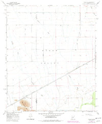
1965 Map of Hyder SE
USGS Topo · Published 1982About this map
Hyder Valley dominates this landscape in the mid-1960s, a desert expanse characterized by the intersection of early transportation and utility corridors. The Southern Pacific railroad cuts diagonally across the arid terrain, passing through the small settlement of Hyder. This rail corridor is paralleled by an extensive Pipeline network, indicating the region's importance as a transit hub for resources moving through southwestern Arizona. To the southeast, Main Camp appears near the base of the Agua Caliente Mts, serving as a localized point of activity within the wider valley.
Find a feature on this map
13 named features on this map. Tap any name to fly to it.
Don’t see what you’re looking for? This feature index may not catch every label — zoom into the map to look around manually.
Map Details
Editions of this 1965 Hyder SE Map
3 editions found
Other maps of this area

1927 · Hyder
USGS Topo · 1:62,500

1929 · Aztec
USGS Topo · 1:62,500

1930 · Hyder
USGS Topo · 1:62,500

1942 · Vicksburg
USGS Topo · 1:250,000

1949 · Sentinel
USGS Topo · 1:62,500

1950 · Sentinel
USGS Topo · 1:62,500

1950 · Aztec
USGS Topo · 1:62,500

1951 · Dendora Valley
USGS Topo · 1:62,500

1953 · Ajo
USGS Topo · 1:250,000

1954 · Phoenix
USGS Topo · 1:250,000