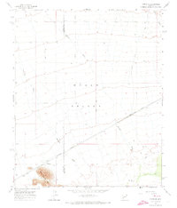
1965 Map of Hyder SE
USGS Topo · Published 1973About this map
Hyder sits at the southern edge of the desert floor, where the Southern Pacific railroad cuts a straight line through the arid landscape of Hyder Valley. This 1965 field-checked survey reveals a territory defined by its hydrology and infrastructure, with the Yuma Co Maricopa Co boundary line running through a series of extensive desert washes. To the southwest, the Agua Caliente Mts rise sharply from the valley floor, providing a stark topographical contrast to the surrounding flats.
Find a feature on this map
12 named features on this map. Tap any name to fly to it.
Don’t see what you’re looking for? This feature index may not catch every label — zoom into the map to look around manually.
Map Details
Editions of this 1965 Hyder SE Map
3 editions found
Other maps of this area

1927 · Hyder
USGS Topo · 1:62,500

1929 · Aztec
USGS Topo · 1:62,500

1930 · Hyder
USGS Topo · 1:62,500

1942 · Vicksburg
USGS Topo · 1:250,000

1949 · Sentinel
USGS Topo · 1:62,500

1950 · Sentinel
USGS Topo · 1:62,500

1950 · Aztec
USGS Topo · 1:62,500

1951 · Dendora Valley
USGS Topo · 1:62,500

1953 · Ajo
USGS Topo · 1:250,000

1954 · Phoenix
USGS Topo · 1:250,000