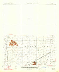
1930 Map of Hyder
USGS Topo · Published 1947About this map
The Southern Pacific railroad cuts across the arid landscape of the Palomas Plain, serving as the primary corridor for commerce and travel through this remote stretch of the Arizona desert. At the center of this movement is Hyder, a small desert settlement established along the tracks. The map illustrates a transitional period when travel relied heavily on historical routes like the Old Yuma-Phoenix Road and the Palomas Harquahala Road, which provided vital links between isolated outposts.
Find a feature on this map
11 named features on this map. Tap any name to fly to it.
Don’t see what you’re looking for? This feature index may not catch every label — zoom into the map to look around manually.
Map Details
Editions of this 1930 Hyder Map
3 editions found
Other maps of this area

1927 · Hyder
USGS Topo · 1:62,500

1929 · Aztec
USGS Topo · 1:62,500

1930 · Stoval
USGS Topo · 1:62,500

1930 · Hyder
USGS Topo · 1:62,500

1942 · Vicksburg
USGS Topo · 1:250,000

1949 · Sentinel
USGS Topo · 1:62,500

1950 · Sentinel
USGS Topo · 1:62,500

1950 · Stoval
USGS Topo · 1:62,500

1950 · Aztec
USGS Topo · 1:62,500

1951 · Dendora Valley
USGS Topo · 1:62,500