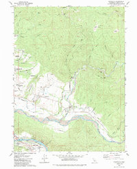
1979 Map of Hydesville
USGS Topo · Published 1985About this map
The confluence of the Van Duzen River and the Eel River shapes the landscape of southern Humboldt County, where industrial and agricultural life centers on the river flats. The Northwestern Pacific Railroad follows the winding riverbanks, connecting timber-focused settlements like Scotia and Rio Dell at the foot of the Scotia Bluffs. Further north, the town of Hydesville sits atop a plateau overlooking the valley, while Carlotta serves as a hub near the junction of Yager Creek and Wilson Creek.
Find a feature on this map
47 named features on this map. Tap any name to fly to it.
Don’t see what you’re looking for? This feature index may not catch every label — zoom into the map to look around manually.
Map Details
Editions of this 1979 Hydesville Map
2 editions found
Other maps of this area

1919 · Glynn
USGS Topo · 1:62,500

1921 · Dyerville
USGS Topo · 1:62,500

1922 · Kneeland
USGS Topo · 1:62,500

1944 · Fortuna
USGS Topo · 1:62,500

1949 · Eureka
USGS Topo · 1:250,000

1949 · Weott
USGS Topo · 1:62,500

1950 · Iaqua Buttes
USGS Topo · 1:62,500

1950 · Scotia
USGS Topo · 1:62,500

1951 · Scotia
USGS Topo · 1:62,500

1951 · Weott
USGS Topo · 1:62,500