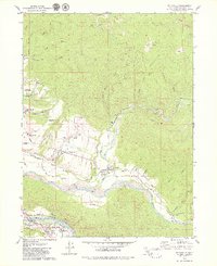
1979 Map of Hydesville
USGS Topo · Published 1979About this map
Hydesville and the surrounding timber and dairy country of Humboldt County are documented here during the late 1970s. The landscape is defined by the convergence of the Van Duzen River and the Eel River, where the towns of Scotia and Rio Dell sit near the striking Scotia Bluffs. The map illustrates the industrial character of the era, showing numerous burners and a logging road network feeding the local timber economy, while the Northwestern Pacific Railroad follows the river grades. This survey provides excellent genealogical detail for the area, identifying the Rohnerville Cemetery, IOOF Cem, and the Town Cem, alongside civic landmarks like the Cuddeback Sch and Rohnerville Indian Rancheria. From the open spaces of Blanton Prairie to the residential streets of Belleview, the map records a specific moment of transition between traditional industry and the growing communities of the redwood coast.
Find a feature on this map
54 named features on this map. Tap any name to fly to it.
Don’t see what you’re looking for? This feature index may not catch every label — zoom into the map to look around manually.
Map Details
Editions of this 1979 Hydesville Map
2 editions found
Other maps of this area

1919 · Glynn
USGS Topo · 1:62,500

1921 · Dyerville
USGS Topo · 1:62,500

1922 · Kneeland
USGS Topo · 1:62,500

1944 · Fortuna
USGS Topo · 1:62,500

1949 · Eureka
USGS Topo · 1:250,000

1949 · Weott
USGS Topo · 1:62,500

1950 · Iaqua Buttes
USGS Topo · 1:62,500

1950 · Scotia
USGS Topo · 1:62,500

1951 · Scotia
USGS Topo · 1:62,500

1951 · Weott
USGS Topo · 1:62,500