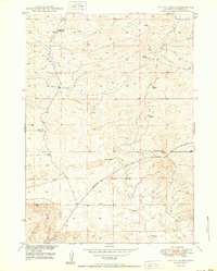
1950 Map of Hylton Ranch
USGS Topo · Published 1950About this map
Hylton Ranch stands as a primary landmark in this ranching region of Converse County, mapped shortly after World War II. The landscape is defined by its seasonal water sources and the extraction of local resources, featuring several Windmills scattered across the terrain to support livestock. The presence of a Coal Mine (Inactive) and another unnamed Coal Mine north of the Glenrock-Ross Road indicates the early industrial attempts to tap into the area's geological potential.
Find a feature on this map
10 named features on this map. Tap any name to fly to it.
Don’t see what you’re looking for? This feature index may not catch every label — zoom into the map to look around manually.
Map Details
Editions of this 1950 Hylton Ranch Map
2 editions found
Other maps of this area

1949 · Careyhurst
USGS Topo · 1:24,000

1949 · Parkerton
USGS Topo · 1:24,000

1949 · Glenrock
USGS Topo · 1:24,000

1949 · Leuenberger Ranch
USGS Topo · 1:24,000

1949 · Glenrock NW
USGS Topo · 1:24,000

1949 · Hylton Ranch
USGS Topo · 1:24,000

1950 · Careyhurst
USGS Topo · 1:24,000

1950 · Leuenberger Ranch
USGS Topo · 1:24,000

1950 · Parkerton
USGS Topo · 1:24,000

1950 · Glenrock NW
USGS Topo · 1:24,000