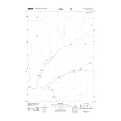
2011 Map of Hyndman Peak
USGS Topo · Published 2011About this map
Hyndman Peak dominates the high-altitude skyline of the Pioneer Mountains in this modern topographic study of Blaine County. The landscape is defined by its dramatic drainage networks, where the East Fork Wood River meets tributaries like Cove Creek and Finley Creek. Human activity is concentrated along the canyon floors, marked by recreational sites such as Hyndman Campground, Sawmill Campground, and Federal Gulch Campground. Traces of earlier industrial efforts remain at the Lucky Gulch Mine, while the high country features the solitary Pioneer Cabin. The map details a complex system of timber and mineral access routes, including Hyndman Creek Rd and Cove Creek Rd, which navigate the deep recesses of Paymaster Gulch and Larkspur Gulch.
Find a feature on this map
35 named features on this map. Tap any name to fly to it.
Don’t see what you’re looking for? This feature index may not catch every label — zoom into the map to look around manually.
Map Details
Editions of this 2011 Hyndman Peak Map
This is the sole edition of this map. No revisions or reprints were ever made.
Other maps of this area

1895 · Hailey
USGS Topo · 1:125,000

1897 · Hailey
USGS Topo · 1:125,000

1955 · Hailey
USGS Topo · 1:250,000

1959 · Hailey
USGS Topo · 1:250,000

1962 · Hailey
USGS Topo · 1:250,000

1967 · Rock Roll Canyon
USGS Topo · 1:24,000

1967 · Baugh Creek SW
USGS Topo · 1:24,000

1967 · Baugh Creek
USGS Topo · 1:24,000

1967 · Sun Valley
USGS Topo · 1:24,000
1967 · Grays Peak
USGS Topo · 1:24,000