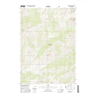
2017 Map of Hyndman Peak
USGS Topo · Published 2017About this map
Hyndman Peak and Cobb Peak dominate the northeastern reaches of the Pioneer Mountains, where high-elevation drainage systems define the landscape. This 2017 survey shows a network of named draws and gulches, including Paymaster Gulch and Federal Gulch, which feed into the E Fork Wood River valley. The map details the transition from the high peaks of the Sawtooth National Forest down to the river basin, tracing the paths of Hyndman Cr and Johnstone Cr. Access to these remote canyons is marked by specialized routes such as Hyndman Creek Rd and Cove Creek Rd, reflecting the modern management of these public lands. Smaller features like Bear Gulch and Sawmill Gulch provide specific reference points for those studying the drainage patterns and local naming conventions of this high-mountain terrain.
Find a feature on this map
44 named features on this map. Tap any name to fly to it.
Don’t see what you’re looking for? This feature index may not catch every label — zoom into the map to look around manually.
Map Details
Editions of this 2017 Hyndman Peak Map
This is the sole edition of this map. No revisions or reprints were ever made.
Other maps of this area

1895 · Hailey
USGS Topo · 1:125,000

1897 · Hailey
USGS Topo · 1:125,000

1955 · Hailey
USGS Topo · 1:250,000

1959 · Hailey
USGS Topo · 1:250,000

1962 · Hailey
USGS Topo · 1:250,000

1967 · Rock Roll Canyon
USGS Topo · 1:24,000

1967 · Baugh Creek SW
USGS Topo · 1:24,000

1967 · Baugh Creek
USGS Topo · 1:24,000

1967 · Sun Valley
USGS Topo · 1:24,000
1967 · Grays Peak
USGS Topo · 1:24,000