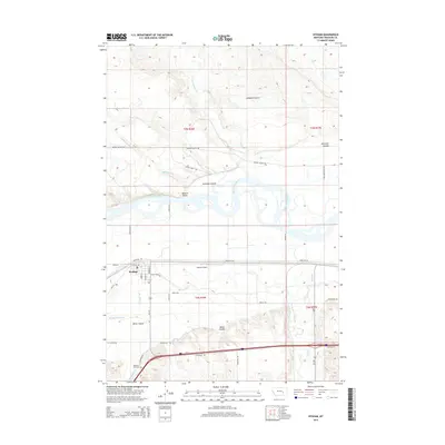
2014 Map of Hysham
USGS Topo · Published 2014About this map
Hysham serves as the focal point of this Treasure County landscape, situated south of a winding stretch of the Yellowstone River. The town's grid, featuring streets like Elliot Ave and Buford St, is positioned between the river and a complex network of agricultural irrigation and natural drainages. To the south, Memorial Vale Cem and the Hysham Airport sit near the base of the rising hills, while the Hysham Main Canal and Box Elder Ditch reflect the vital role of water management in this high plains environment. The northern portion of the map is dominated by a series of rugged draws and coulees, such as Johnston Coulee and Antelope Coulee, that drain toward the river. This 2014 survey documents the enduring layout of rural Treasure County, from the small settlement at Mission Valley to the isolated homesteads along Sarpy Farm Rd and Cut Across Rd.
Find a feature on this map
41 named features on this map. Tap any name to fly to it.
Don’t see what you’re looking for? This feature index may not catch every label — zoom into the map to look around manually.
Map Details
Editions of this 2014 Hysham Map
This is the sole edition of this map. No revisions or reprints were ever made.
Other maps of this area

1954 · Forsyth
USGS Topo · 1:250,000

1957 · Forsyth
USGS Topo · 1:250,000

1958 · Forsyth
USGS Topo · 1:250,000

1960 · Hysham
USGS Topo · 1:24,000

1960 · Steie Ranch
USGS Topo · 1:24,000

1960 · Vananda
USGS Topo · 1:24,000

1960 · Ahles
USGS Topo · 1:24,000

1960 · Myers
USGS Topo · 1:24,000

1960 · Sanders
USGS Topo · 1:24,000

1960 · Eldering Ranch
USGS Topo · 1:24,000