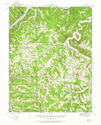
1933 Map of Iberia
USGS Topo · Published 1965About this map
The Osage River cuts across the northwest corner of this Miller County landscape, passing the Cedar Bluffs and the county seat of Tuscumbia. Surveyed in the early 1930s, the terrain is defined by a dense network of ridges and hollows, such as Turn Back Ridge and Shoestring Hollow, which dictated the settlement patterns of the era. Uplands are dotted with numerous small rural schools like Stumpf Sch and Tygal Sch, reflecting a time when educational hubs were localized within walking distance of farmsteads.
Find a feature on this map
85 named features on this map. Tap any name to fly to it.
Don’t see what you’re looking for? This feature index may not catch every label — zoom into the map to look around manually.
Map Details
Editions of this 1933 Iberia Map
2 editions found
Other maps of this area

1888 · Versailles
USGS Topo · 1:125,000

1888 · Tuscumbia
USGS Topo · 1:125,000

1893 · Versailles
USGS Topo · 1:125,000

1894 · Tuscumbia
USGS Topo · 1:125,000

1904 · Eldon
USGS Topo · 1:62,500

1932 · Versailles No 4
USGS Topo · 1:48,000

1933 · Stoutland
USGS Topo · 1:62,500

1933 · Iberia
USGS Topo · 1:62,500

1934 · Toronto
USGS Topo · 1:24,000

1934 · Bagnell
USGS Topo · 1:24,000