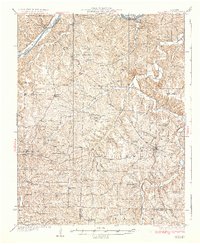
1937 Map of Iberia
USGS Topo · Published 1937About this map
The Osage River winds through the northwestern corner of this landscape, flanked by the high river bluffs of Tuscumbia and the Cedar Bluffs. This 1930s survey captures a deeply dissected terrain of the Ozark Plateau where ridge-top farming and valley-floor settlements like Iberia and Brumley were connected by a dense network of country schools and churches. The map documents a rural social structure anchored by numerous local institutions, including the Mt Zion Ch and the Tuscumbia School.
Find a feature on this map
99 named features on this map. Tap any name to fly to it.
Don’t see what you’re looking for? This feature index may not catch every label — zoom into the map to look around manually.
Map Details
Editions of this 1937 Iberia Map
2 editions found

Other maps of this area

1888 · Versailles
USGS Topo · 1:125,000

1888 · Tuscumbia
USGS Topo · 1:125,000

1893 · Versailles
USGS Topo · 1:125,000

1894 · Tuscumbia
USGS Topo · 1:125,000

1904 · Eldon
USGS Topo · 1:62,500

1932 · Versailles No 4
USGS Topo · 1:48,000

1933 · Stoutland
USGS Topo · 1:62,500

1933 · Iberia
USGS Topo · 1:62,500

1934 · Toronto
USGS Topo · 1:24,000

1934 · Bagnell
USGS Topo · 1:24,000