
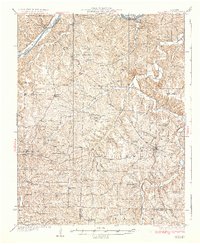
1937 Map of Iberia
USGS Topo · Published 1937About this map
Iberia serves as the focal point for this 1930s survey of the Missouri Ozarks, situated amidst a landscape defined by the deep winding valleys of Tavern Creek and the Osage River. The map reveals a dense network of rural infrastructure typical of the early twentieth century, including a high concentration of country school districts such as Spearman Sch, Oak Hill Sch, and Mountain View Sch. Communities like Ulman and St Anthony appear as established hubs, while the rural interior is dotted with family-named landmarks and local centers of worship like Mt Zion Ch and Clover Chapel. The terrain's complexity is illustrated by the Numerous hollows and branches, including Shoestring Hollow and Blue Spring Branch, which dictated the early road patterns and settlement locations long before modern development altered the region's character.
Find a feature on this map
68 named features on this map. Tap any name to fly to it.
Don’t see what you’re looking for? This feature index may not catch every label — zoom into the map to look around manually.
Map Details
Editions of this 1937 Iberia Map
2 editions found
Other maps of this area

1888 · Versailles
USGS Topo · 1:125,000

1888 · Tuscumbia
USGS Topo · 1:125,000

1893 · Versailles
USGS Topo · 1:125,000

1894 · Tuscumbia
USGS Topo · 1:125,000

1904 · Eldon
USGS Topo · 1:62,500

1932 · Versailles No 4
USGS Topo · 1:48,000

1933 · Stoutland
USGS Topo · 1:62,500

1933 · Iberia
USGS Topo · 1:62,500

1934 · Toronto
USGS Topo · 1:24,000

1934 · Bagnell
USGS Topo · 1:24,000