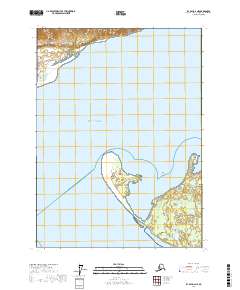
2017 Map of Icy Bay D-2 NE
USGS Topo · Published 2017About this map
Alaska Maritime National Wildlife Refuge dominates the coastal reaches of this 2017 survey, where the dynamic interface between glacial silt and the Gulf of Alaska shapes the shoreline. The landforms here, including the prominent Point Riou Spit and the nearby Tsimpshian Point, illustrate the shifting geography of Riou Bay. These coastal features are part of a complex maritime environment where land and water are in constant flux, a fact further evidenced by the positioning of Moraine Island and the shallow hazards of Moraine Reef.
Find a feature on this map
13 named features on this map. Tap any name to fly to it.
Don’t see what you’re looking for? This feature index may not catch every label — zoom into the map to look around manually.
Map Details
Editions of this 2017 Icy Bay D-2 NE Map
This is the sole edition of this map. No revisions or reprints were ever made.
Other maps of this area

1948 · Icy Bay D-2 and D-3
USGS Topo · 1:63,360

1950 · Bering Glacier
USGS Topo · 1:250,000

1950 · Icy Bay
USGS Topo · 1:250,000

1951 · Icy Bay D-2 and D-3
USGS Topo · 1:63,360

1951 · Icy Bay
USGS Topo · 1:250,000

1951 · Bering Glacier
USGS Topo · 1:250,000

1951 · Bering Glacier A-2
USGS Topo · 1:63,360
1959 · Icy Bay D-2 and D-3
USGS Topo · 1:63,360

1959 · Bering Glacier
USGS Topo · 1:250,000

1959 · Bering Glacier A-2
USGS Topo · 1:63,360