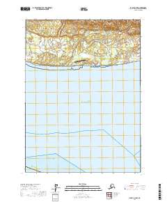
2017 Map of Icy Bay D-2 NW
USGS Topo · Published 2017About this map
Icy Bay Airport sits on a narrow coastal strip where the Alaskan wilderness meets the sea, serving as a critical point of access in the Yakutat Borough. The landscape is defined by the braided drainage patterns of the Big River and Priest River, which flow from the interior highlands across a marshy coastal plain toward the Gulf of Alaska. Near the eastern edge of this shoreline, Claybluff Point marks a distinct geological feature where the terrain begins to rise. This 2017 survey details the complex hydrography of the region, including Crystal Cr and Watson Cr, illustrating the dynamic interface between glacial runoff and the open waters of the Pacific Ocean.
Find a feature on this map
14 named features on this map. Tap any name to fly to it.
Don’t see what you’re looking for? This feature index may not catch every label — zoom into the map to look around manually.
Map Details
Editions of this 2017 Icy Bay D-2 NW Map
This is the sole edition of this map. No revisions or reprints were ever made.
Other maps of this area

1948 · Icy Bay D-2 and D-3
USGS Topo · 1:63,360

1950 · Bering Glacier A-3
USGS Topo · 1:63,360

1950 · Bering Glacier
USGS Topo · 1:250,000

1950 · Icy Bay
USGS Topo · 1:250,000

1951 · Icy Bay D-2 and D-3
USGS Topo · 1:63,360

1951 · Icy Bay
USGS Topo · 1:250,000

1951 · Bering Glacier
USGS Topo · 1:250,000

1951 · Bering Glacier A-2
USGS Topo · 1:63,360
1959 · Icy Bay D-2 and D-3
USGS Topo · 1:63,360

1959 · Bering Glacier
USGS Topo · 1:250,000