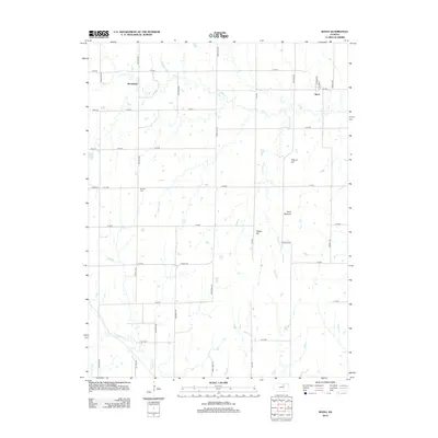
2012 Map of Idana
USGS Topo · Published 2012About this map
Idana and Browndale anchor this section of Clay County, where the agricultural grid meets the drainage systems of the Kansas plains. The landscape is defined by the winding course of Five Cr and Pinkerton Br, which eventually flow toward Chapman Cr in the south. Unlike the flatter prairies elsewhere, this area features distinctive topographic landmarks such as Potato Hill, Tobyne Hill, and the Table Mounds, which rise above the surrounding farmland. These elevations provided natural vantage points in an otherwise uniform landscape. For local historians, the location of Shields Cem on 14th Rd offers a specific point of interest for genealogical research, while the well-defined road network, including Co Hwy-827 and named routes like Deer Trail Rd, shows the modern connectivity of these rural communities.
Find a feature on this map
32 named features on this map. Tap any name to fly to it.
Don’t see what you’re looking for? This feature index may not catch every label — zoom into the map to look around manually.
Map Details
Editions of this 2012 Idana Map
This is the sole edition of this map. No revisions or reprints were ever made.
Other maps of this area

1891 · Clay Center
USGS Topo · 1:125,000

1955 · Manhattan
USGS Topo · 1:250,000

1956 · Manhattan
USGS Topo · 1:250,000

1957 · Manhattan
USGS Topo · 1:250,000
1964 · Industry
USGS Topo · 1:24,000

1964 · Clay Center NW
USGS Topo · 1:24,000

1964 · Clay Center SW
USGS Topo · 1:24,000

1964 · Idana
USGS Topo · 1:24,000

1964 · Miltonvale
USGS Topo · 1:24,000

1964 · Miltonvale NE
USGS Topo · 1:24,000