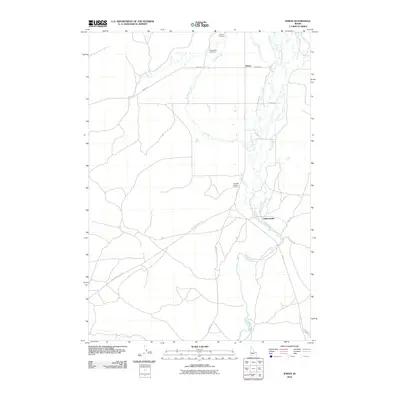
2010 Map of Idmon
USGS Topo · Published 2010About this map
Idmon and the small settlement of Eighteenmile serve as the primary human touchpoints in this pocket of Clark County, where the landscape is defined by the converging drainages of Camas Creek, Spring Creek, and Crooked Creek. The map documents a predominantly rural ranching or agricultural layout, anchored by the Kilgore Cemetery and the nearby New Kilgore Cemetery in the north. A network of local corridors like Idmon Rd and Red Rd connects these isolated outposts across the high plains. A singular geological feature, Cinder Butte, rises near the center of the sheet, providing a distinct landmark in an otherwise riparian-dominated terrain. The layout of the roads, such as Stoddard Ln and Jensen Ln, suggests a grid of property boundaries and local homesteads typical of the region's development into the early 21st century.
Find a feature on this map
19 named features on this map. Tap any name to fly to it.
Don’t see what you’re looking for? This feature index may not catch every label — zoom into the map to look around manually.
Map Details
Editions of this 2010 Idmon Map
This is the sole edition of this map. No revisions or reprints were ever made.
Other maps of this area

1955 · Dubois
USGS Topo · 1:250,000

1955 · Ashton
USGS Topo · 1:250,000

1958 · Dubois
USGS Topo · 1:250,000

1958 · Ashton
USGS Topo · 1:250,000

1960 · Ashton
USGS Topo · 1:250,000

1964 · Dubois NE
USGS Topo · 1:24,000

1972 · Pine Butte
USGS Topo · 1:24,000
1972 · Split Rock
USGS Topo · 1:24,000

1972 · Antelope Valley
USGS Topo · 1:24,000

1972 · Kilgore
USGS Topo · 1:24,000