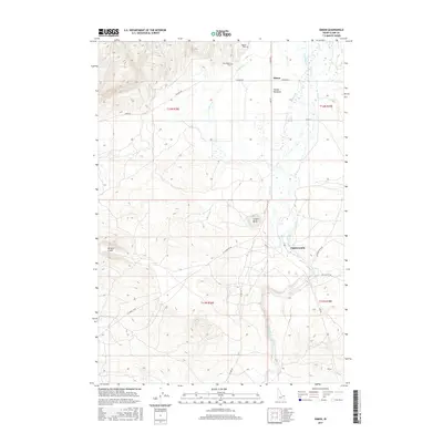
2017 Map of Idmon
USGS Topo · Published 2017About this map
Camas Meadows dominates this section of Clark County, defining a wide basin where Camas Cr and Spring Cr converge. The settlement of Idmon serves as a central point for local travel, situated at the junction of Red Rd and Stoddard Ln. The landscape is a distinct mix of volcanic geology and riparian wetlands, featuring prominent landmarks like Cinder Butte and the circular depression of Morgan Crater to the west. For genealogists and local historians, the proximity of both Kilgore Cem and New Kilgore Cem near Crooked Cr provides a specific focal point for tracing the area's early residents. The road network, including Kilgore Rd and Eighteen Mile Rd, underscores the rural nature of this high-elevation meadow system, which remains largely shaped by its seasonal waterways and volcanic history.
Find a feature on this map
24 named features on this map. Tap any name to fly to it.
Don’t see what you’re looking for? This feature index may not catch every label — zoom into the map to look around manually.
Map Details
Editions of this 2017 Idmon Map
This is the sole edition of this map. No revisions or reprints were ever made.
Other maps of this area

1955 · Dubois
USGS Topo · 1:250,000

1955 · Ashton
USGS Topo · 1:250,000

1958 · Dubois
USGS Topo · 1:250,000
1958 · Ashton
USGS Topo · 1:250,000
1960 · Ashton
USGS Topo · 1:250,000
1964 · Dubois NE
USGS Topo · 1:24,000
1972 · Pine Butte
USGS Topo · 1:24,000
1972 · Split Rock
USGS Topo · 1:24,000
1972 · Antelope Valley
USGS Topo · 1:24,000
1972 · Kilgore
USGS Topo · 1:24,000