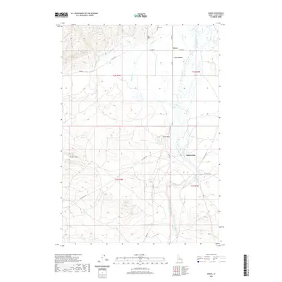
2020 Map of Idmon
USGS Topo · Published 2020About this map
Idmon and the surrounding high-altitude wetlands of eastern Clark County are defined by a complex network of waterways, including Camas Meadows and the meandering Camas Cr. This volcanic landscape is marked by geological features such as Morgan Crater to the west and Cinder Butte toward the center, revealing the area's igneous origins. Local history is anchored by the Kilgore Cem and New Kilgore Cem near the northern boundary, while small settlements like Eighteenmile are connected by a grid of rural routes including Red Rd and A-2 Clark Co Rd. The terrain transitions from these alluvial meadows into more broken ground to the north, where Crooked Cr cuts through the rising elevation. The prominence of these water-rich meadows suggests a long history of seasonal grazing and ranching in this high Idaho valley.
Find a feature on this map
26 named features on this map. Tap any name to fly to it.
Don’t see what you’re looking for? This feature index may not catch every label — zoom into the map to look around manually.
Map Details
Editions of this 2020 Idmon Map
This is the sole edition of this map. No revisions or reprints were ever made.
Other maps of this area

1955 · Dubois
USGS Topo · 1:250,000

1955 · Ashton
USGS Topo · 1:250,000

1958 · Dubois
USGS Topo · 1:250,000

1958 · Ashton
USGS Topo · 1:250,000

1960 · Ashton
USGS Topo · 1:250,000

1964 · Dubois NE
USGS Topo · 1:24,000

1972 · Pine Butte
USGS Topo · 1:24,000
1972 · Split Rock
USGS Topo · 1:24,000

1972 · Antelope Valley
USGS Topo · 1:24,000

1972 · Kilgore
USGS Topo · 1:24,000