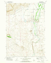
1972 Map of Idmon
USGS Topo · Published 1976About this map
Camas Meadows dominates the central landscape of this early 1970s Idaho survey, where the wandering path of Camas Creek meets the rugged volcanic features of the Snake River Plain. The map documents the small settlement of Idmon and the historic reach of Eighteenmile, illustrating a high-desert ranching environment defined by wide open spaces and seasonal water sources like Crooked Creek. Genealogy researchers will find the local burial grounds of Kilgore Cem and the New Kilgore Cem clearly marked near the northern boundary.
Find a feature on this map
16 named features on this map. Tap any name to fly to it.
Don’t see what you’re looking for? This feature index may not catch every label — zoom into the map to look around manually.
Map Details
Editions of this 1972 Idmon Map
This is the sole edition of this map. No revisions or reprints were ever made.
Other maps of this area

1955 · Dubois
USGS Topo · 1:250,000

1955 · Ashton
USGS Topo · 1:250,000

1958 · Dubois
USGS Topo · 1:250,000

1958 · Ashton
USGS Topo · 1:250,000

1960 · Ashton
USGS Topo · 1:250,000

1964 · Dubois NE
USGS Topo · 1:24,000

1972 · Pine Butte
USGS Topo · 1:24,000
1972 · Split Rock
USGS Topo · 1:24,000

1972 · Antelope Valley
USGS Topo · 1:24,000

1972 · Kilgore
USGS Topo · 1:24,000