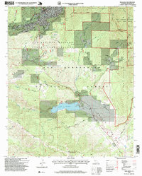
1996 Map of Idyllwild
USGS Topo · Published 1999About this map
Idyllwild and Fern Valley serve as the primary mountain retreats on this 1990s-era map, situated among the high peaks of the San Bernardino National Forest. The local economy and culture are defined by institutions like the Idyllwild School of Performing Arts and the Desert Sun School, alongside numerous working properties such as Fleming Ranch and Garner Ranch. The dramatic verticality of the landscape is traced by Strawberry Creek Road and the Pines to Palms Highway, which connects the high mountain communities to the valley below. Southward, the topography levels into Garner Valley, dominated by the expanse of Lake Hemet and its associated dam. This survey provides a clear view of the complex management boundaries between the Tahquitz National Game Preserve, the San Jacinto Wilderness, and state-managed refuge lands during a period of established conservation and recreation.
Find a feature on this map
61 named features on this map. Tap any name to fly to it.
Don’t see what you’re looking for? This feature index may not catch every label — zoom into the map to look around manually.
Map Details
Editions of this 1996 Idyllwild Map
This is the sole edition of this map. No revisions or reprints were ever made.
Other maps of this area

1901 · Southern California Sheet No. 1
USGS Topo · 1:250,000

1901 · San Jacinto
USGS Topo · 1:125,000

1904 · Southern California Sheet No. 1
USGS Topo · 1:250,000

1940 · Palm Springs
USGS Topo · 1:62,500

1940 · Hemet Reservoir
USGS Topo · 1:62,500

1942 · Banning
USGS Topo · 1:62,500

1942 · Hemet Reservoir
USGS Topo · 1:62,500

1942 · Hemet
USGS Topo · 1:62,500

1943 · Hemet
USGS Topo · 1:62,500

1943 · Banning
USGS Topo · 1:62,500
Featured Places
- Idyllwild, Idyllwild-Pine Cove
- Mountain Center, CA
- Idyllwild-Pine Cove, CA
- Riverside County, CA
- United States