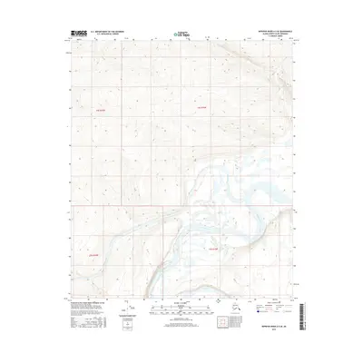
2016 Map of Ikpikpuk River A-5 SE
USGS Topo · Published 2016About this map
The Colville River and the Awuna River meet in this 2016 survey of the North Slope, revealing the complex braiding and oxbow formations of these Arctic waterways. The confluence marks a significant hydrological junction within the National Petroleum Reserve in Alaska, where the meandering path of the Awuna River enters the broader Colville River valley. The terrain is characterized by a dense network of contour lines that detail the subtle elevation changes of the surrounding tundra and river bluffs. This map captures the remote landscape between t4s r16w and t5s r15w, providing an intricate view of the riverbanks and riparian zones before they were altered by subsequent seasonal floods or permafrost shifts.
Find a feature on this map
6 named features on this map. Tap any name to fly to it.
Don’t see what you’re looking for? This feature index may not catch every label — zoom into the map to look around manually.
Map Details
Editions of this 2016 Ikpikpuk River A-5 SE Map
This is the sole edition of this map. No revisions or reprints were ever made.
Other maps of this area

1951 · Ikpikpuk River
USGS Topo · 1:250,000

1951 · Killik River
USGS Topo · 1:250,000

1956 · Killik River
USGS Topo · 1:250,000

1956 · Ikpikpuk River
USGS Topo · 1:250,000

1984 · Killik River D-5
USGS Topo · 1:63,360
1984 · Ikpikpuk River A-4
USGS Topo · 1:63,360
1984 · Ikpikpuk River A-5
USGS Topo · 1:63,360
1986 · Killik River D-4
USGS Topo · 1:63,360
2016 · Killik River D-4 NW
USGS Topo · 1:25,000
2016 · Killik River D-5 NW
USGS Topo · 1:25,000