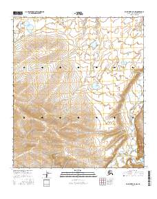
2016 Map of Killik River D-4 NW
USGS Topo · Published 2016About this map
The Kurupa River cuts through this remote stretch of the North Slope, revealing a landscape defined by dramatic elevation changes and a complex hydrological network. While the southern portion of the sheet is dominated by the steep contours of the surrounding ridges, the northern section transitions into a basin characterized by scattered ponds and meandering drainage patterns typical of the Arctic tundra. The presence of Heather Creek in the southeastern corner further emphasizes the natural drainage systems that have shaped this terrain over millennia. The map provides a detailed view of the Public Land Survey System boundaries, including the intersection of t5s r15w and t6s r14w, illustrating how this wilderness is historically partitioned and managed within the North Slope Borough.
Find a feature on this map
6 named features on this map. Tap any name to fly to it.
Don’t see what you’re looking for? This feature index may not catch every label — zoom into the map to look around manually.
Map Details
Editions of this 2016 Killik River D-4 NW Map
This is the sole edition of this map. No revisions or reprints were ever made.
Other maps of this area

1951 · Ikpikpuk River
USGS Topo · 1:250,000

1951 · Killik River
USGS Topo · 1:250,000

1956 · Killik River
USGS Topo · 1:250,000

1956 · Ikpikpuk River
USGS Topo · 1:250,000

1984 · Killik River D-5
USGS Topo · 1:63,360
1984 · Ikpikpuk River A-4
USGS Topo · 1:63,360
1984 · Ikpikpuk River A-5
USGS Topo · 1:63,360
1986 · Killik River D-4
USGS Topo · 1:63,360
2016 · Killik River D-4 SW
USGS Topo · 1:25,000
2016 · Killik River D-5 SE
USGS Topo · 1:25,000