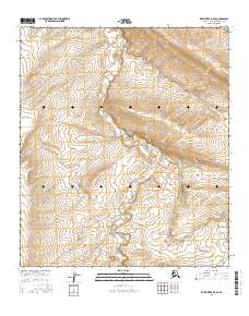
2016 Map of Killik River D-5 SE
USGS Topo · Published 2016About this map
Kucher Cr serves as the central geographic thread through this remote Arctic landscape in the North Slope Borough. This 2016 survey documents a vast expanse of high-latitude terrain where the winding course of the creek creates the primary topographic variation within the survey boundaries. The map defines several township and range blocks including t7s r15w and t7s r16w, illustrating the systematic public land grid applied to this undeveloped wilderness. Without roads, buildings, or named landmarks beyond the waterway, the document focuses on the natural hydrology and contour of the tundra, providing a baseline for researchers and environmental historians tracking shifts in the Alaskan interior.
Find a feature on this map
7 named features on this map. Tap any name to fly to it.
Don’t see what you’re looking for? This feature index may not catch every label — zoom into the map to look around manually.
Map Details
Editions of this 2016 Killik River D-5 SE Map
This is the sole edition of this map. No revisions or reprints were ever made.
Other maps of this area

1951 · Killik River
USGS Topo · 1:250,000

1956 · Killik River
USGS Topo · 1:250,000

1984 · Killik River D-5
USGS Topo · 1:63,360
1984 · Killik River C-5
USGS Topo · 1:63,360
1986 · Killik River C-4
USGS Topo · 1:63,360
1986 · Killik River D-4
USGS Topo · 1:63,360
2016 · Killik River D-4 NW
USGS Topo · 1:25,000
2016 · Killik River D-5 SW
USGS Topo · 1:25,000
2016 · Killik River D-4 SW
USGS Topo · 1:25,000
2016 · Killik River C-4 NW
USGS Topo · 1:25,000