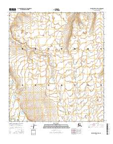
2016 Map of Killik River D-5 SW
USGS Topo · Published 2016About this map
The East Fork Etivluk River winds through the southwestern corner of this survey, representing the primary hydrological feature in an otherwise largely unpopulated expanse of the Alaska North Slope. This 2016 production by the U.S. Geological Survey details a landscape defined by subtle elevation changes and the Public Land Survey System grids, including t6s r17w, t7s r17w, and t8s r17w. The map illustrates the characteristic drainage patterns of the region's arctic tundra, where small ponds and seasonal watercourses navigate the contours between low ridges. For those studying the geography of the North Slope Borough, the map provides precise data on the township and range boundaries such as t7s r16w and t8s r16w, which are essential for locating specific wilderness tracts in this interior territory.
Find a feature on this map
7 named features on this map. Tap any name to fly to it.
Don’t see what you’re looking for? This feature index may not catch every label — zoom into the map to look around manually.
Map Details
Editions of this 2016 Killik River D-5 SW Map
This is the sole edition of this map. No revisions or reprints were ever made.
Other maps of this area

1951 · Howard Pass
USGS Topo · 1:250,000

1951 · Killik River
USGS Topo · 1:250,000

1956 · Howard Pass
USGS Topo · 1:250,000

1956 · Killik River
USGS Topo · 1:250,000

1984 · Howard Pass D-1
USGS Topo · 1:63,360

1984 · Howard Pass C-1
USGS Topo · 1:63,360

1984 · Killik River D-5
USGS Topo · 1:63,360
1984 · Killik River C-5
USGS Topo · 1:63,360
2016 · Howard Pass D-1 SE
USGS Topo · 1:25,000
2016 · Howard Pass D-1 NE
USGS Topo · 1:25,000