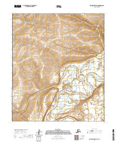
2020 Map of Ikpikpuk River A-5 SE
USGS Topo · Published 2020About this map
The Colville River carves a massive, winding path through the southern half of this Arctic landscape, demonstrating the complex hydrologic patterns of the North Slope. This 2020 survey documents the confluence region where the Awuna River joins the larger drainage from the west. The terrain is defined by low-lying wetlands and river bars within the vast plains of t5s r15w and t5s r16w. The intricate network of braided channels and seasonal ponds captured here is characteristic of this sub-Arctic environment, providing a detailed record of the river's geomorphology before shifting freeze-thaw cycles further alter the banks of these remote waterways.
Find a feature on this map
6 named features on this map. Tap any name to fly to it.
Don’t see what you’re looking for? This feature index may not catch every label — zoom into the map to look around manually.
Map Details
Editions of this 2020 Ikpikpuk River A-5 SE Map
This is the sole edition of this map. No revisions or reprints were ever made.
Other maps of this area

1951 · Ikpikpuk River
USGS Topo · 1:250,000

1951 · Killik River
USGS Topo · 1:250,000

1956 · Killik River
USGS Topo · 1:250,000

1956 · Ikpikpuk River
USGS Topo · 1:250,000

1984 · Killik River D-5
USGS Topo · 1:63,360
1984 · Ikpikpuk River A-4
USGS Topo · 1:63,360
1984 · Ikpikpuk River A-5
USGS Topo · 1:63,360
1986 · Killik River D-4
USGS Topo · 1:63,360
2016 · Killik River D-4 NW
USGS Topo · 1:25,000
2016 · Killik River D-5 NW
USGS Topo · 1:25,000